
REVIEW · TUCSON AUDIO TOURS
Mount Lemmon Self-Guided Driving Audio Tour
The mountain changes every few minutes. This self-guided drive turns the 30-mile climb from Tucson into a moving lesson in geology, ecology, history, and local trails. You follow the Catalina Highway at your own pace while more than 44 audio stories start automatically as you reach each point of interest.
I like the way the tour explains the dramatic change from Sonoran Desert to alpine forest. I also like the hands-free GPS system, which lets you keep your eyes on the road instead of stopping to read directions. The main drawback is that the narration works best while driving uphill on the set route. The descent can confuse the timing, and a few pullouts may appear just after you pass them.
For $16.99 per car, with up to four people included, this is an excellent value for a couple or family. You get lifetime access, offline maps, and the freedom to stop for food, photos, walks, or a quiet look across the valley. Just download the app before leaving strong cellular or Wi-Fi service.
Key Things to Know Before You Go
- The route climbs about 6,000 feet: You move through several climate zones, almost like driving from southern Arizona toward Canada.
- More than 44 audio stories fill the drive: The narration covers plants, wildlife, geology, trails, Cold War history, and scenic overlooks.
- The best direction is uphill: Start in Tucson and follow the route toward Mount Lemmon Ski Valley and the SkyCenter Observatory.
- One purchase covers the car: The $16.99 price applies to a group of up to four people, not each passenger.
- The audio needs preparation: Download the separate Action Tour Guide app and the tour while you still have a strong connection.
- You can use it again and again: Access does not expire, so you can pause, return another day, or repeat the drive on a future trip.
Why This Mount Lemmon Drive Is Worth Your Time
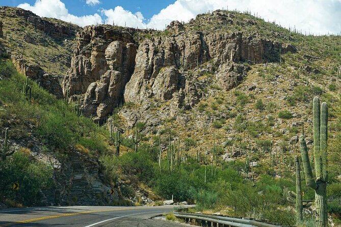
Mount Lemmon is not just a road to a mountain viewpoint. The Catalina Highway crosses a huge range of elevation, and the scenery changes with it. At the lower end, you see saguaros, prickly pears, chollas, and ocotillos. Higher up, grasses and shrubs take over. Near the summit, ponderosa pines, aspens, and cooler mountain air define the trip.
The audio gives those changes a useful explanation. Instead of seeing a cactus one minute and a pine tree the next without context, you learn how elevation affects temperature, water, soil, and plant life. One especially helpful point is that the drive gains around 6,000 feet, creating the feel of a journey from south to north in a relatively short distance.
The route takes about two to three hours without long stops. That estimate can stretch if you hike, picnic, fish at Rose Canyon Lake, or spend time at the overlooks. You control the pace, which is far more useful here than a fixed bus schedule.
The narration is also a good match for this road. The voice is pleasant, the stories are timed to points along the highway, and the audio usually advances by GPS without requiring you to tap the screen. You still need to obey the speed limit and avoid getting ahead of the narration. Staying at the recommended pace helps the stories arrive at the right places.
More Self-Guided Audio Tours in the USA
- Gettysburg Battlefield Self-Guided Driving Audio Tour
★ 4.5 · 910 reviews - Joshua Tree National Park Self-Guided Driving Audio Tour
★ 4.5 · 762 reviews - Ultimate Acadia National Park Self-Guided Driving Audio Tour
★ 4.0 · 521 reviews
Starting at Soldier Trail and Babad Do’ag
The tour begins at 9070 East Catalina Highway in Tucson. No guide meets you there. You simply open the Action Tour Guide app, select the Mount Lemmon route, and drive to the first story point.
Soldier Trail introduces the hiking side of the mountain. This five-mile out-and-back route climbs about 2,000 feet and passes through classic desert plants, including saguaros and prickly pears. The audio makes clear that this is a challenging walk, not a casual stroll. If you are only driving, the stop still gives you a quick sense of how quickly the foothills rise above Tucson.
Babad Do’ag Scenic Overlook is one of the first major photo stops. From here, you can look across the city and toward the surrounding mountains. The nearby Babad Do’ag Trail is a moderate 4.5-mile walk through saguaros, chollas, and ocotillos.
This is a good early stop because it shows the desert at its most familiar before the road begins to feel more wooded and mountainous. If you are planning to stop often, use this section to check that your phone is connected to the car stereo and that the audio is playing at a comfortable volume.
Molino Canyon and the First Big Change in Vegetation
At Molino Canyon Vista, the road has reached roughly 4,000 feet. The plants begin to look different here, and the audio explains why. You may see native grasses, slender ocotillos, desert broom, and pink fairy duster, a flowering shrub with a memorable name and appearance.
Molino Canyon itself is filled with boulders and sits within the Catalina Mountains. The overlook does not require an admission ticket, and the five-minute audio segment gives you enough context to appreciate the change without turning the stop into a lecture.
The nearby Molino Basin Trail is a relatively flat five-mile out-and-back route. It works well for trail runners and mountain bikers, while walkers should allow a little more than two hours. I like this stop for visitors who want a short outdoor activity without committing to a steep climb.
Bug Spring Trailhead offers a much harder option. The ten-mile out-and-back route climbs about 2,000 feet, beginning in desert foothills and moving toward pine forest, creek crossings, and Bear Canyon Picnic Area. It can take about five hours, so this is not a quick break during the audio drive. Treat it as a separate hiking plan.
Thimble Peak, Seven Cataracts, and Bear Canyon
Thimble Peak Vista is one of the more entertaining stops because the landmark really does resemble a giant sewing thimble. The peak rises above 5,000 feet, and the overlook gives you a bird’s eye view of the canyon.
Seven Cataracts refers to a series of waterfalls along Willow Canyon stream. The total drop is about 1,000 feet, but the water falls in many smaller steps rather than one sheer plunge. The audio helps you picture the formation, although the amount of water you see can vary.
Middle Bear Picnic Area is a practical stop, especially if you packed lunch. Ponderosa pines shelter the picnic area beside Bear Canyon, and the opposite slope has unusual rock formations shaped by erosion and landslides. This is one of the best places to pause the tour, eat, and let the scenery do some of the work.
The ability to pause matters here. You are not tied to a group schedule, and you do not lose access to the next story simply because you stopped for sandwiches. The app is designed for breaks and side trips.
More Driving Audio Tours in the USA:
- Ultimate Lake Tahoe Self-Guided Driving Audio Tour
★ 4.5 · 435 reviews - Scenic Newport, RI Self-Guided Driving Audio Tour
★ 4.5 · 325 reviews - Arches National Park Self-Guided Driving Audio Tour
★ 4.5 · 288 reviews - Yellowstone National Park Self-Guided Driving Audio Tour
★ 4.5 · 249 reviews
Manzanita Vista and Windy Point
Manzanita Vista introduces a plant that looks almost polished. Manzanita trees have smooth red bark and twisted branches. They survive in poor soil with little water, and the audio explains how that tough adaptation lets them grow where many other plants cannot.
Windy Point is one of the strongest scenic stops on the route. From here, you can see the broad sweep from the desert at the mountain’s base to the cooler upper reaches. It is a useful place to understand the whole trip in one view, since the drive has carried you through several plant zones.
Allow more time at Windy Point than the basic audio segment requires. The story itself takes about ten minutes, but the viewpoint deserves a careful look and perhaps a few photographs. Keep an eye on the road and parking conditions, since the tour points out stops as you approach them, and the GPS can be momentarily less helpful if you turn around.
Hoodoos, Duck Head Rock, and Rose Canyon Lake
The Geology Vista Point and Hoodoo Vista focus on tall, narrow rock spires called hoodoos. These formations develop in dry, hot climates, and the Catalina Mountains offer several striking examples. At both stops, use the marked turnout and avoid stopping in an unsafe place simply to catch a view.
Duck Head Rock is a lighter moment along the route. The formation resembles a duck’s head and long bill, making it easy to spot and fun for families. These small visual surprises help keep the drive engaging, especially for children who may not care much about elevation data.
Rose Canyon Lake changes the mood again. Arizona is not usually the first place you associate with fishing, but this quiet mountain lake offers that option. It tends to be calmer than the most famous stops along the highway, making it a useful place to take a slower break.
The audio does not replace local rules, permits, or reservations where those are required. Attraction passes, entry tickets, and reservations are not included in the tour price, so check those details separately before planning a fishing stop or special activity.
San Pedro Vista and the Arizona National Scenic Trail
San Pedro Vista looks across the San Pedro Valley. On a clear day, the view reaches far beyond the immediate mountain slopes, giving you a better sense of the distance between the Catalina and Galiuro ranges.
The overlook also connects with the Arizona National Scenic Trail, an 800-mile route running from the Mexican border to Utah. You do not need to hike the entire trail, of course. The value here is the context: a short stop on the Mount Lemmon road touches a trail system that crosses the entire state.
There is also a practical restroom option at the Palisades Visitor Center. The route directs you to turn onto East Organization Ridge Road if you need a break. This is a small detail, but it helps when you are planning a long mountain drive with children or several passengers.
Butterfly Trail and Aspen Vista
Butterfly Trail is an 11-mile challenge with a memorable side story. About three miles in, an unofficial trail leads toward a crashed F86 fighter jet from 1957. The audio raises the obvious question of how a military aircraft ended up on the mountain, adding a touch of mystery to an already scenic hike.
Because the aircraft route is unofficial and the main trail is long, do not treat this as a quick roadside walk. The tour introduces the story, but it does not turn a demanding hike into an easy attraction.
Aspen Vista sits close to 8,000 feet. On a clear day, the view can reach about 50 miles, including the Galiuro Mountains. Between the two mountain ranges lies a valley dropping more than 5,000 feet, with the San Pedro River running through it.
This is where the altitude change becomes most obvious. The air and vegetation feel far removed from the saguaros near Tucson. You do not need to be a geology student to appreciate it, though the audio gives enough explanation to make the change more than a visual trick.
Red Ridge, Ski Valley, and the Cold War Past
Red Ridge Trail gets its name from the red dirt beneath your feet. The color comes from iron-bearing minerals weathering in the soil, much like rust on metal. The ten-mile route is rated moderate, so it is better suited to hikers who have planned for a longer outing rather than people making a quick stop between viewpoints.
Mount Lemmon Ski Valley marks the upper end of the road and offers winter sports in the alpine part of Arizona. The presence of a ski resort is a useful reminder of how sharply the climate changes during the climb. You can begin the day among desert cacti and end near a ski area.
The route ends beside the Mount Lemmon SkyCenter Observatory at 9800 East Ski Run Road. The final history segment explains that the site began as a Cold War radar station in 1956. For ten years, it operated as the highest continually operating radar station in the world, with about 80 men living there full-time.
That story gives the summit a human layer. Mount Lemmon was not only a place for scenery and recreation. Its height also made it valuable for watching the skies during a tense period in American history.
App Setup, Timing, and the Main Weak Spots
Download the separate Action Tour Guide app before you leave reliable service. After booking, you receive setup instructions and a password by email and text. Search for audio tour if the message is hard to find.
You can connect your phone to the car with Bluetooth, USB, or AUX. The tour works with Apple CarPlay, while Android Auto support is listed as forthcoming. An iPhone running iOS 15 or later, an Android device running version 9 or later, or an iPad or tablet with GPS and cellular service is recommended.
The route is hands-free once it is running. Stories trigger based on your location, and offline maps continue to work after the tour has been downloaded. This is important on a mountain road, where cellular service may not be dependable.
The biggest issue is route direction. The audio is built around the uphill drive from Tucson toward Mount Lemmon. On the way down, the timing may not match the points of interest. If you pass a pullout, turning around can also confuse the app for a short time.
Start early enough to avoid feeling rushed. Drive at the posted speed, leave room for photo stops, and pause the audio when you take a side trip. The tour gives you lifetime access, so there is no need to force every trail and overlook into one afternoon.
Who Gets the Best Value at $16.99?
The price is strong because it covers the entire car, up to four people. A couple pays less than they would for two individual guided tickets, and a family of four gets especially good value. You also avoid the fixed timing and group movement of a traditional tour.
This suits independent visitors who want information but do not want a guide sitting beside them. It also works well for families because you can pause for snacks, skip a story, or stop at a picnic area without holding anyone else up.
The tour is less suitable if you want a live guide, a carefully managed schedule, or a route that works equally well in both directions. It is also not a substitute for hiking information, trail permits, or attraction reservations. Think of it as a smart audio companion for the drive, not an all-purpose mountain pass.
Should You Book the Mount Lemmon Audio Tour?
I would book it if you plan to drive Mount Lemmon from Tucson and want more than pretty pullouts. The narration adds useful detail about the plants, rock formations, trails, radar station, and dramatic rise in elevation. The GPS timing and per-car price make it easy to recommend for couples and families.
Download everything before you start, use the uphill route, and expect the drive to take longer than two hours if you stop often. If you can accept those limits, this is one of the simplest ways to give the Catalina Highway more meaning without giving up control of your day.
Free cancellation is available up to 24 hours before the scheduled start time. Cancellations inside that window are not refundable.
FAQ
How much does the Mount Lemmon audio tour cost?
The tour costs $16.99 per group, covering up to four people in one car.
How long does the tour take?
The drive takes about two to three hours without extended stops. Hiking, picnics, fishing, and photo breaks will make the outing longer.
Where does the tour start?
It starts at 9070 East Catalina Highway in Tucson, Arizona.
Where does the tour finish?
The route ends at 9800 East Ski Run Road beside the Mount Lemmon SkyCenter Observatory.
Is the tour guided in person?
No. This is a private, self-guided activity. No guide meets you at the starting point.
Does the tour work without cell service?
Yes, if you download the tour and maps while you have strong Wi-Fi or cellular service. The audio and offline maps are designed to work after downloading.
Is the tour available in languages other than English?
The tour is offered in English.
Can I use the tour more than once?
Yes. Access does not expire, and you can use the tour on different days or future trips.
Just added around the USA
- Self Guided Driving Audio Tour of Saguaro National Park★ 3.0 · 4 reviews
- Self-Guided Audio Driving Tour of Mount Lemmon★ 5.0 · 4 reviews
- Saguaro National Park Self-Guided Audio Tour★ 3.5 · 11 reviews
- A Self Guided Audio Tour in Tombstone★ 4.0 · 11 reviews
- Catskills Scenic Byway Self-Guided Driving Audio Tour★ 4.0 · 9 reviews
- Big Bend National Park Self Guided Audio Tour Guide★ 5.0 · 12 reviews
- Self-Guided Audio Driving Tour in Catskills Scenic Byway★ 4.5 · 7 reviews
- Shiloh Battlefield Self-Guided Driving Audio Tour★ 4.0 · 9 reviews
Driving Audio Tours, compared.



Ultimate Acadia National Park Self-Guided Driving Audio Tour
Read our review →



Browse the lists this tour appears in